- Home
- BLOG POST
- Contact Us
- HEADLINES NEWS STORIES
- SOCIAL MEDIA NEWS STORIES
- EDUCATIONAL RESOURCES
- #2 HEADLINE NEWS STORIES
- RECOMMENDED BOOKS TO READ
- EXPERTS SPEAKERS VIDEOS
- EVENTS IN CALIFORNIA
- PAWS TO READ PROGRAM
- GGUSD & OCTA SAFE ROUTE
- #3 NEWS ARTICLES/RESOURCE
- #2 EDUCATIONAL RESOURCES
- #3 EDUCATION RESOURCES
- #4 NEWS ARTICLES
- PODCAST RADIO/VIDEO
- ENVIRONMENTAL WELLNESS ED
- G.G. CA.CLIMATE CHANGE
- PDF BLOG POST FILES
- G.G. CONCEPT VETERAN DOG
- #3 HEADLINE NEWS STORYS
- HISTORY MILITARY WITH DOG
- #2 ABOUT HISTORY VETERANS
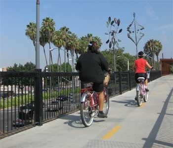
- BICYCLES /WALKING SAFETY
- #3 HISTORY VETERANS
- G.G. WAR DOG/K-9 PARK
- #4 VETERANS HISTORY
- RAIL TO TRAIL COVID 19
- PUBLIC RECORDS ACT GOV
- GARDEN GROVE DOWN TOWN
- #2 DOWN TOWN GARDEN GROVE
- BIKE PEDESTERIAN SAFTEY
- BLOG POST
- #2 GGUSD
- GARFFITI/BLIGHT OCTA/G.G.
- GARDEN GROVE SAFTEY
- EDUCATIONAL PDF DOCUMENTS
- GARDEN GROVE BIKE TRAIL
- CITY G.G. CA MEDAL BIKE
- MEMORAIL MEDAL OF HONOR
- Blank
- Blank
About Safe Routes to School

Solano Safe Routes to School – Your Kids. Your School. Your Community. What are the Benefits? The number of children who walk or bike to school in the U.S. has steadily decreased over the last 50 years. At the same time communities, including Solano County, are seeing increases in traffic around schools, air pollution, and childhood obesity. To help address these problems, the Solano Transportation Authority (STA) launched the Solano County Safe Routes to School program in 2008. In partnership with Solano County Public Health, the program brings together city planners, traffic engineers, law enforcement, educators and parents to encourage walking and biking to school by creating safer, less congested routes to school.
Safe Routes to School programs can:
- Increase the number of children walking and biking to school safely
- Reduce traffic congestion and improve air quality around schools
- Increase daily physical activity levels and reduce obesity and other health risks
- Improve academic performance among children
The Safe Routes to School program offers a wide range of free programs, activities and events for schools.
Successful Safe Routes to School programs include each of the 6 E’s
- Education – ensures children, parents and the community know how to walk, bike and drive safely.
- Engineering – makes sure the streets and sidewalks around schools are built for safety.
- Encouragement – makes it fun for children, parents and the community to walk and bike.
- Enforcement – ensures traffic laws and school policies are followed.
- Evaluation – checks the progress of the program and makes changes as needed.
- Engagement – emphasizes the importance of involving schools, parents, youth and other key stakeholders in the process to ensure program sustainability.

High School Youth Engagement
In 2017, Solano Safe Routes to School (SR2S) launched the Youth Engagement Pilot Program to support high school aged youth in Solano County.
Since the SR2S Program has traditionally focused on supporting elementary school youth, this Youth Engagement Program was designed to:
- increase high school youth leadership and involvement in Safe Routes to School activities countywide and;
- engage in youth-led projects that can lead to sustainable solutions in improving active transportation and safety, reducing carbon emissions and/or addressing Safe Routes to School goals such as increasing walking, biking or physical activity.
Participating sites will be asked to engage in a YPAR (Youth-Led Participatory Action Research) or Photovoice Project following an easy-to-follow curriculum provided to them by SR2S. The SR2S team will work with participants to build capacity and skills for young people and their adult counterparts that will potentially increase youth-led activities and promotion of the Safe Routes to School program countywide.
More information and program application is available below or contact us at:
707-399-3222 or solanosr2sinfo@sta.ca.gov
What is a Bike Rodeo?
A Bike Rodeo is a fun, active event for elementary students to learn biking and safety skills in a safe and comfortable environment. Safe Routes to School staff sets up various agility courses on school grounds for students to practice important skills necessary to ride a bike safely and confidently. Staff also inspects students’ bikes and makes sure their bike helmets fit them properly.
Kindergarten through 6th grade students must be able to ride a bike without assistance to participate. Students should bring their own bike and helmet to the Bike Rodeo, but bikes and helmets can be provided, if needed. Bike Rodeos last 1-2 hours depending on the number of participants. Schools are required to provide 6-10 volunteers to help the event run smoothly.
For more information or to schedule a Bike Rodeo at your school, contact the Safe Routes to School program at (707) 399-3222 or solanosr2sinfo@sta.ca.gov.
Vision Zero increasing safe, healthy, severe injuries,
What is Safe Routes to School?
Safe Routes to School programs can:
- Increase the number of children walking and biking to school safely
- Reduce traffic congestion and improve air quality around schools
- Increase daily physical activity levels and reduce obesity and other health risks
- Improve academic performance among children
The Safe Routes to School program offers a wide range of free programs, activities and events for schools.
Successful Safe Routes to School programs include each of the 6 E’s
- Education – ensures children, parents and the community know how to walk, bike and drive safely.
- Engineering – makes sure the streets and sidewalks around schools are built for safety.
- Encouragement – makes it fun for children, parents and the community to walk and bike.
- Enforcement – ensures traffic laws and school policies are followed.
- Evaluation – checks the progress of the program and makes changes as needed.
- Engagement – emphasizes the importance of involving schools, parents, youth and other key stakeholders in the process to ensure program sustainability.
Pedestrian and Bicycle SafetyPedestrian and bicycle safety remains an important traffic safety issue in an ever-changing transportation landscape that accommodates all types of road users. According to a 2019 Governors Highway Safety Association report, pedestrian traffic fatalities in California increased by 12% from 2018 to 2019. OTS funds programs that promote safe behaviors and the use of roadways when walking or biking. Programs target all age groups to raise awareness about traffic rules, rights, and responsibilities whether you are driving, on foot or on bikes. Specifically, programs are designed for high-risk populations, including youth and older community members, all in an effort to teach safer driving, bicycling, and walking behaviors. Activities for youth include bicycle trainings and walking courses to build skills that make children comfortable getting to and from school. Additional outreach targets underserved and older communities to identify safety issues
PEDESTRIAN AND BICYCLE SAFETY PROGRAM AREA GOALS
- Reduce the total number of pedestrians killed.
- Reduce the total number of pedestrians injured.
- Reduce the number of pedestrians killed under the age of 15.
- Reduce the number of pedestrians injured under the age of 15.
- Reduce the number of pedestrians killed over the age of 65.
- Reduce the number of pedestrians injured over the age of 65.
- Reduce the total number of bicyclists killed in traffic related crashes.
- Reduce the total number of bicyclists injured in traffic related crashes.
- Reduce the number of bicyclists killed in traffic related crashes under the age of 15.
- Reduce the number of bicyclists injured in traffic related crashes under the age of 15.
- Increase bicycle helmet compliance for children aged 5 to 18.

Cupertino Union School District Safe Routes to School
Safe Routes to School is an international movement to make it safe, convenient and fun for children and families to choose healthier, active, and sustainable school commutes. The goal of Safe Routes to School is to get more children bicycling and walking to schools every day. This improves personal health, benefits the environment, increases safety, and decreases traffic congestion around schools. The Cupertino Union School District continues to build partnerships with the cities where our students live (Cupertino, Los Altos, Santa Clara, San Jose, Saratoga, and Sunnyvale) so that we can all make sure our students are traveling to and from school in the healthiest way possible.
Even if you have to get to school by car, there are still options for you to help reduce congestion and make your commute less stressful.
This section of the website contains community-based information to help CUSD parents learn how to start their children biking and walking to school safely, to give volunteers the information they need to get involved, and to provide links to important community resources.
Cupertino Safe Routes to School

Cupertino Union School District is located in Santa Clara County, California. Cupertino Union School District
Cupertino Union School District Partnering with City of Cupertino is committed to safeguarding community members of all ages as they navigate our diverse network of bikeways, roadways, and walkways. To ensure that we achieve this goal, we are actively working on expanding beyond the traditional infrastructure and enforcement approach to traffic safety. This unique approach has led to the creation of Cupertino Safe Routes to School, a program that brings together various stakeholders to address student safety throughout the City.
OCT. 14, 1999 12 AM The third annual bicycle rodeo sponsored by the Garden Grove Police Department will take place from 10 a.m. to 2 p.m. Saturday. The rodeo will feature a bicycle safety course and instructions on proper helmet fitting and bicycle safety. Information: (714) 741-5731.
he CPBST, a joint project of UC Berkeley SafeTREC and California Walks, trains local neighborhood residents and safety advocates in how to improve pedestrian and bicycle safety and strengthen their collaboration with local officials and agency staff to make California communities safer and more pleasant to walk and bike. This interactive map provides summary reports where available for each training, highlighting workshop proceedings, as well as ideas and recommendations for pedestrian/bicycle safety projects, policies, and programs in each community. Funding for this project was provided by a grant from the California Office of Traffic Safety, through the National Highway Traffic Safety Administration.
The Safe Routes to School Program
Based on the needs and feedback from cities and schools for small-scale project support, the Solano SR2S Program has received approval from the STA Board to pilot a SR2S Micro-Grant Program to begin in fiscal year 2019-2020. The funds awarded through this program will support small-scale projects or capital purchases that encourage bike and pedestrian usage and improve bike and pedestrian safety around Solano County schools. The SR2S Micro-Grant Pilot Program will be funded through Transportation Development Act (TDA) funds, air district grants and High-Occupancy Vehicle (HOV) fines.
This grant opportunity is open to all Solano County cities, schools, school districts, community organizations and youth groups. Projects could include (but are not limited to): purchasing and installing bike racks and safety-related signage; providing safety equipment (bike helmets, vests, reflectors); creating green bike lanes or making other infrastructure improvements at/around schools.
Micro-Grant Project Awards (2019-2020)
The Safe Routes to School Program received 16 grant applications totaling $211,466 in funding requests, exceeding the amount of available funds. Due to the strong interest to fund smaller scale projects, staff is planning to recommend continuing the program next fiscal year. Below is the list of projects awarded funding:
- City of Vacaville: radar feedback signs
- City of Vallejo: radar feedback signs
- Browns Valley Elementary (Vacaville): bike and scooter racks
- Dan Mini Elementary (Vallejo): safety signage and equipment, walk/bike incentives
- Dixon Montessori Charter School (Dixon): safety signage and equipment, bike rack and walk/bike incentives
- Everest Academy (Vallejo): safety equipment, walk/bike incentives
- Joe Henderson Elementary (Benicia): high visibility crosswalk improvements
- Kairos Public Schools (Vacaville): safety signage and equipment, walk/bike incentives
- Knight Middle School (Dixon): bike racks
- Mary Farmar Elementary (Benicia): safety signage and equipment
- Riverview Middle School (Rio Vista): bike corral fencing and scooter storage
- Sierra Vista K-8 (Vacaville): incentives promoting physical activity events
- Solano-Widenmann K-8 (Vallejo): walk/bike incentives
- Vaca Pena Middle School (Vacaville): scooter racks
Basic Riding Skills -- PA Safe Routes Bicycle Safety Video #2
Through Pennsylvania's Safe Routes to School program, a series of five videos promoting bicycle safety was developed. Video 2, "Basic Riding Skills," is targeted at elementary school students and their parents. This video describes the essential skills such as braking, balancing, turning, hand signals and selecting safe travel routes to school.
Let's Go Biking! Lesson 1: Get Ready to Ride
This video reviews the following key concepts: -Why People Ride -Ask an Adult
Pedestrian Safety
BIKEWAY & WALKABILITY COMMITTEE The mission of this committee is to: Focus on the review and update of the City's Master Plan of Bikeways and improvements to be made to bikeways in the City; and Evaluate the bikeability and walkabiltiy of our City in order to make recommendations for improvement to the City Council
The Bikeway and Walkability Committee was formed by the City Council on April 7, 2015. The Committee will help plan and implement a robust Active Transportation network for the City by improving bicycle and pedestrian connectivity throughout the City. The City is currently updating its General Plan and the changes/updates recommended by this committee will be incorporated in General Plan and presented to the City Council for final approval and adoption.
Safer Systems America Walks, in partnership with UNC Highway Safety Research Center, is excited to launch the Safer Systems program in 2018. The program will help selected communities assess, plan, and prioritize effective and context-sensitive safety treatments to reduce the growing numbers of pedestrian fatalities and injuries. Following a year of implementation, America Walks and its partners will share the results of the technical assistance and provide an outline of lessons learned and cultivate inspiration for other cities looking to address pedestrian safety.
Your Action Matters
America Walks’ network of organizations, local advocates and dedicated supporters are the strength of the movement to a walkable America. We are proud to be able to provide the resources and information available to enable this network to make lasting change in their own communities. Be sure to visit our Learning Center to explore the latest resources available and continue to support our Current Action.
Pedestrian Safety
The problem of pedestrians being killed or seriously injured on California roadways is bad and growing worse. Most people think that car drivers are usually at fault in pedestrian crashes, but the crash reports show that pedestrian mistakes account for nearly as many crashes as do drivers. There are more people out walking – to get to work, school and shopping or just for fun, exercise, and being outside. In an era where we are promoting walking as a healthy, positive, and community building alternative to driving, walking is becoming increasingly dangerous. The Office of Traffic Safety, together with our partners at the State Transportation Agency, Caltrans, CHP, DMV and concerned organizations and advocates across the state, wants to bring awareness to the California public about the dangers pedestrians face so that injuries and fatalities can be reduced on roadways.
2018: 893 pedestrians were killed on California roadways, a 26% increase from 2014.
- 2018: More than 14,000 pedestrians injured.
- Pedestrian deaths rose 26% percent between 2014 and 2018.
- Nearly 7,500 pedestrians have died in California between 2009 and 2018.
- California’s pedestrian fatality rate is almost 25% higher than the national average.
- No state has more pedestrian deaths on its roadways than California.
The Alameda County Safe Routes to Schools (SR2S) Program organizes and supports fun, educational activities that encourage families to walk, bike, carpool, and take transit to school. We’ve created this Resource Center to be a hub of information and materials for parents, teachers, school administrators, and program champions to build and sustain SR2S programs in their schools and communities. To get started, check out the simple step-by-step guide below! We’ve created a number of resources to help you and your students stay active and healthy during the coronavirus pandemic. Click here to check them out!
Our mission is to strive for Healthy Kids, Safer Streets, Strong Communities. The Alameda County Safe Routes to Schools Program works in schools across Alameda County to develop school travel programs that make sense for their communities.
- We teach kids the basics of walking and biking safely.
- We make walking and biking to school fun with special events.
- We help communities identify traffic investments to make their communities safer.
We began in 2006 as a grant-funded pilot program in Oakland, California. The pilot was implemented by TransForm, a local non-profit organization. Today, we serve over 250 public schools in Alameda County, teaching students from elementary school to high school the joys and benefits of choosing active and shared transportation options to get to school. Our program is managed, administered and funded by the Alameda County Transportation Commission and is implemented by a fantastic team of Safe Routes to Schools experts and professionals working together to fulfill our mission for healthy kids, safer streets, and stronger communities.
Are you ready for an adventure? The Orange County Transportation Authority is planning fun bike workshops to explore local communities. All workshops are free and include bike skills guidance, tips and tricks and a fun ride to explore the treasures of Orange County! The goal of the workshops is to help you ride more safely and with more confidence during everyday travel and recreation. To sign up for classes that will be offered in 2020 please contact Peter Sotherland, Active Transportation Coordinator, at psotherland@octa.net or (714) 560-5386.
OCTA has prioritized the advancement of active transportation in Orange County, which includes bikeways planning, safety programs and community events. Each year, we celebrate National Bike Month in May with local events, bicycling promotions and more. Whether you bike to work or school, for exercise or recreation – bicycling is a fun, healthy and efficient way to travel in Orange County.
Top 10 Bike Safety Rules for Kids | Safe On Wheels
Steinberg Law Firm Continues Campaign to Prevent Bicycle Injuries to Kids | Safe On Wheels Most clients seek help from a personal injury attorney after they have suffered an injury. The attorneys and staff of the Steinberg Law firm are dedicated to preventing injury before they happen, especially injuries to the children of our community. We are very excited to provide preventative safety measures and education to our children in the lowcountry area. As our population continues to grow, our streets become more crowded with pedestrians, cars and trucks, and bicycles. We welcome these new residents and hope they find Charleston as charming as we do, however, this means a rise in traffic collisions too often involving our children riding bicycles. Without the proper safety gear, a bicycle accident is much more likely to result in a serious head or spine injury
Residents of the Five Wounds/Brookwood Terrace neighborhoods first expressed an interest in converting the railroad line that runs through their neighborhoods into a trail for pedestrians and cyclists in 1999 and in 2006 made the rail-to-trail idea a "top ten" priority.
$4.14 million for Five Wounds Trail
 Great news! The VTA Board of Directors has approved a grant of $4.14 million dollars for the environmental, planning and design work needed to advance our project! Congratulations and thanks to Yves Zsutty and San José’s Department of Parks, Recreation and Neighborhood Services for their fine work on the grant application and to the VTA Board of Directors, especially Raul Peralez, Sam Liccardo and Cindy Chavez, for helping get the grant over the finish line. By the way, one criterion for approval of the grant was community engagement–that’s YOU! All those cleanups, all those meetings. We’re making progress! Happy Trails!
Feedback wanted on Safe Routes 2 School The City of Cupertino has listed safe routes to and from local schools (highlighted in green), including Lincoln Elementary, in the dotted square, Kennedy Middle School and Monta Vista High School, as part of their Safe Routes 2 School program. (courtesy City of Cupertino)
Cupertino is seeking feedback on a program that aims to make it safer for students to walk or bicycle to and from school.
The city has released a survey to gauge parents’ awareness of its Safe Routes 2 School program and find ways to improve it.
Launched as an experiment in 2015 as a way to localize the national effort, Safe Routes 2 School was expanded the following year to include all Cupertino schools.
The program has brought together educators, parents, students, city planners and engineers to assess the traffic conditions around schools and come up with projects to protect students from accidents.
News Whittier officials end attempt to expand greenway trai

Whittier officials end attempt to expand Greenway Trail Walter Fletcher of Whittier rides his bicycle on the Greenway Trail westbound from Mills Avenue on Wednesday September 22, 2010. The City of Whittier is officially giving up on negotiations with Union Pacific for property to extend the Greenway trail to the La Habra border.
WHITTIER – City officials have stopped negotiations with Union Pacific in trying to acquire an easement that would allow the Greenway Trail to be extended to the La Habra border.
Assistant City Manager Nancy Mendez said the city is unwilling to agree to Union Pacific’s proposal that Whittier take complete liability for the train and tracks from Mills Avenue east to the city border.
The city proposed to pay for a fence dividing the tracks from the trail and to accept some responsibility, Mendez said.
“(But) they want us to take liability not just on the trail but also on the rest of the Union Pacific property,” she said. “You could have an engineer drunk and texting, jump the tracks and wipe out people on the Greenway Trail and it would be the city’s responsibility,” Mendez said.
The 4.5-mile pedestrian biking trail now extends from Pioneer Boulevard to Mills.
In an e-mailed statement, Aaron Hunt, spokesman for Union Pacific, said walking paths near the tracks represent potential safety risks.
“Those risks carry substantial insurance costs,” Hunt stated. “We require that parties accessing Union Pacific property assume the financial burden of any increased risk.”
The city has been seeking to extend the trail by reaching a deal with Union Pacific for a 15-foot-wide easement next to their railroad tracks.
The existing trail follows an abandoned path.
Whittier to build parking lot at east end of Greenway Trail City officials have secured the money to build a parking lot at the east end of the Greenway Trail at Mills Avenue as it is seen on Tuesday, April 26, 2016. Looking west from the proposed parking lot toward the greenway trail.
WHITTIER >> A long sought after parking lot at the east end of the Greenway Trail is expected to be constructed later this year.
City officials have secured state park grants of nearly $400,000 to build the 22-space parking lot on a nearly half-acre lot at the northeast corner of Mills Avenue and Lambert Road.
“I’m excited that’s going to offer residents more opportunity to use the trail,” said Mayor Fernando Dutra. “The parking lot will offer folks an opportunity to park and ride (a bicycle) or park and walk.
The City Council at its May 10 meeting is expected to award a contract for design of the parking lot and later this year award one for construction.
A parking lot has been proposed for the site for a long time.
The only off-road parking areas now available to trail users are four miles west at Palm Park and two miles west of Mills Avenue in a nine-space lot.
“I think it’s fantastic,” said former Councilman Greg Nordbak, who pushed for the parking lot when he was on the council. “It makes me happy the council kept it on the burner.”
Parking is even more needed now because trail users are parking in nearby business parking lots, in front of residents on adjacent streets and even next to the railroad, said Nancy Mendez, assistant city manager.
“We obviously need a place where people can park,” Mendez said.
The parking lot, to be named Oak Station, also will serve as a rest spot for trail users, including bicycle racks, seating, drinking fountains, security lighting and signage. Signs may include an entry sign, banners hung from light poles, and a trail map.
Whittier Trail Offers a Safer Way to School and a Recreational Resource The City of Whittier won the 2010 Helen Putnam Award for Excellence in the Health and Wellness Programs category. For more about the awards program, visit www.cacities.org/helenputnam
Transforming an abandoned railroad right of way into the Whittier Greenway Trail, a 4.5-mile recreational and commuter bikeway and pedestrian path, took 12 years to plan, fund and build — but it was worth it.
The City of Whittier (pop. 87,128) is located in Los Angeles County, 12 miles southeast of Los Angeles. Nearly 300 traffic collisions occurred between 1995 and 2005 within school zones on the city’s arterial streets. To avoid walking on the streets, many children used an abandoned Union Pacific Railroad right of way to get to school. Along this unsupervised route they encountered criminal activity, including drug use and harassment, along with illegally dumped trash and other hazards.
MAKING THE COMMUNITY SAFER
“The community was anxious to improve the overgrown, vandalized railroad route that traversed the heart of the city and eliminate the crime, homeless camps, trash, graffiti and gang activity that the abandoned property attracted,” says Mayor Greg Nordbak. “Residents campaigned for an off-road bike path so families could safely ride to schools and parks without using major arterial streets.”
Whittier began planning, negotiating and acquiring funds in 1997 to purchase the 4.5-mile abandoned property and develop it into a bicycle and pedestrian trail. The corridor purchase and development were funded with $15 million in federal, state and county grants. The city completed the project and opened the trail in January 2009.
TRAIL OFFERS MULTIPLE AMENITIES
The Whittier Greenway Trail begins on the western city boundary near Los Angeles County’s San Gabriel River Bike Trail and traverses Whittier, linking schools, homes, parks, shopping areas and transit stops. The trail comprises a 12-foot-wide asphalt path for wheeled traffic and a 5-foot-wide decomposed-granite path for pedestrians. The entire trail is ADA accessible and has dog comfort stations, large mile markers and smaller on-path quarter-mile markers to assist visitors with location and distances. Public art and interpretive exhibits dot the trail. Residents use the Whittier Greenway Trail for transportation, recreation and simply enjoying the outdoors.
Safety monitoring is an important component of trail operations. Graffiti, trash and litter are removed seven days a week. For extra security, the Whittier Police Department patrols the trail with small dual-sport motorcycles, and regular police patrols monitor segments of the trail by visual assessment from each intersection.
The Vision of the Great American Rail-Trail
Rails-to-Trails Conservancy
Spanning more than 3,700 miles from Washington, D.C., to Washington State—and traveling through 12 states and the District of Columbia—the Great American Rail-Trail™ will be like nothing that has come before. The nation’s first cross-country multiuse trail, the “Great American” will provide a uniquely American experience, connecting millions to the country’s heritage, it’s beauty and bounty, and its diverse people and places, all from the most personal vantage point: the trail.
Trail Project Assistance Available Through National Park Service
Do you have an idea for a local conservation and outdoor recreation project, but need help to move that vision to reality? Is your budding rail-trail project in need of some expert planning assistance?
Every year, the National Park Service helps hundreds of locally driven projects that create opportunities for healthy outdoor recreation, connect youth with the outdoors, and connect communities to parks.
The Rivers, Trails, and Conservation Assistance (RCTA) program, through the National Park Service, doesn't provide monetary funding for projects, but instead offers what can be priceless expert staff time to help communities plan for success.
That technical assistance could be in the form of helping with:
- building partner relationships;
- developing conceptual, strategic and workable project plans;
- facilitating public participation;
- identifying potential sources of funding;
- "hands-on" conservation and other technical skills.
Assistance is provided for one year and may be renewed for a second year, if warranted.
Applications are now being accepted for the RCTA program. Deadline is August 1.
Visit www.nps.gov/rtca for complete information and application.
Whittier Bicycle Transportation Plan
- Acknowledgments / Table of Contents / Definitions / Background
- Analysis / Scope of Plan / Compliance Requirements
- Appendix / Attachments
- Full Bicycle Transportation Plan
History
In 1972, the Whittier Ad Hoc Bicycling Committee and City staff prepared a Bicycle Routes Plan that was incorporated into the Circulation Element of the Whittier General Plan. The plan was based upon the experience of the committee participants with input from staff and local cycling organizations. The goal of the 1972 plan was the identification of future bikeway facilities throughout the City. A bike route map was also developed but was not consistent with the eventual 1972 plan. In 1982, as the City adopted a Bicycle Master Plan, very few bikeways existed within its boundaries. Since that time, the majority of bikeways identified in the 1982 plan have been developed. In addition to implementing all bikeways within the Master Plan, the City of Whittier Public Works staff had completed additional bikeways not previously addressed in 1982. Many of these routes were additional Class II Bike Lanes that were implemented as part of roadway resurfacing projects. These additional routes were documented and added to the 2008 Bicycle Transportation Plan.
Within the 1993 Whittier General Plan, a Bicycle Plan was included in the Environmental Resources Management Element. The 1993 Plan encouraged the City to provide incentives for alternate modes of transit, pursue the development of additional bikeways, and analyze parking development standards. The 1993 update was not specific about where bikeways could be added and generally brief on guidelines for implementing proposed objectives. Since the implementation of the 1982 Plan, the most significant change is the addition of a Class I trail along the abandoned Union Pacific Railroad (UPRR) line. Although the 1982 Plan discussed the possibility of such as trail, the document indicated the project to be infeasible due the UPPR not allowing bikeways on active railroad right-of-ways and thus redirected its focus on the development of a parallel Class II and Class III bikeway along Lambert Road.